

Free text
ReWio Short
Why perfect-looking peaks are almost certainly natural
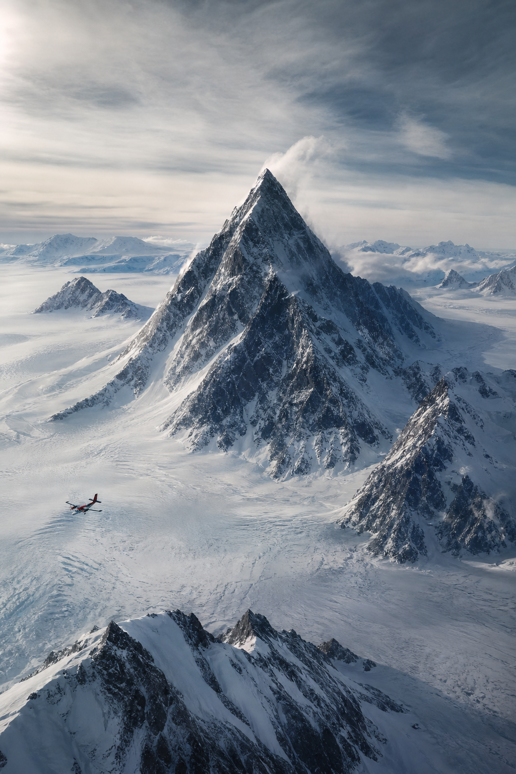
At first glance, the mountain looks almost too neat to be natural. A sharp summit rises above the Antarctic ice, with ridges that seem to run down like the edges of a giant pyramid. In a cropped satellite image, stripped of landmarks and scale, it can feel less like a mountain than a message. That reaction is understandable. It is also where the real investigation begins.
The image most often shared online points to an unnamed, pyramid-shaped peak in the Ellsworth Mountains of West Antarctica. It is not a documented archaeological site. It is not an identified ancient structure. And it should not be casually confused with every other Antarctic mountain that happens to look pointed, or with geographic features that are formally named The Pyramid.
That distinction matters. Antarctica contains many dramatic peaks, nunataks, ridges, and ice-covered rock outcrops. Some have descriptive names involving pyramids because people have long used familiar shapes to name landscapes. One officially gazetteered feature called The Pyramid is a separate peak near Hope Bay on the Trinity Peninsula. It is nowhere near the viral Ellsworth Mountains image. A matching name is not evidence that all these places are one object, one discovery, or one mystery.
So what can actually be established about the viral peak? It lies in a remote, heavily glaciated mountain region. Its visible upper section has a pointed summit and steep faces. It appears unusually symmetrical from some viewpoints. It is surrounded by terrain shaped by ice. And it belongs in an area where geological mapping identifies extensive quartzite bedrock in the Sentinel Range, sculpted into high alpine terrain by glacial erosion.
Those facts may sound less cinematic than an ancient Antarctic civilization. But they are far more interesting, because they explain why the image is so compelling in the first place.
Human vision is exceptionally good at detecting patterns. It has to be. We recognize faces in a crowd, a path through a forest, and danger in a fraction of a second. The tradeoff is that our brains sometimes promote resemblance into identity. A triangular peak resembles a pyramid. Straight-looking ridges resemble constructed edges. Four apparent faces resemble an engineered design. Once that interpretation arrives, every shadow can start to look like a doorway, every dark seam like a joint between blocks.
Satellite images amplify the effect. They offer a view few people ever experience directly, but often without the cues that let us judge terrain properly. There may be no person, tree, building, road, or coastline nearby to reveal scale. Snow can hide the broad lower slopes that connect a summit to the surrounding range. A single angle can make ridges seem straighter, faces seem smoother, and a mountain seem more isolated than it really is.
Light matters too. Low sunlight creates bold shadow boundaries. A ridge that is irregular in three dimensions can look almost ruler-straight in a two-dimensional image. Rotate the view, change the season, alter the snow cover, or zoom out, and the impression can change sharply. Online posts frequently select the one frame in which the peak looks most pyramid-like. They may then combine it with photographs of other Antarctic peaks, maps of separate locations, or claims about named features that are not the same mountain.
None of that means viewers are foolish for noticing the shape. The shape is real. The leap from shape to construction is what needs evidence.
Geologists have a name for a landform like this: a horn, also called a pyramidal peak. The United States Geological Survey defines a horn as a pointed mountain peak, typically pyramidal in shape, bounded by the walls of three or more cirques. A cirque is a bowl-like hollow carved into a mountainside by a glacier. When glaciers erode a mountain from several sides, the walls between those hollows are narrowed into sharp ridges called arêtes. What remains at their intersection can be a steep, pointed summit.
Think of ice not as a passive blanket, but as a slow-moving abrasive system. Glaciers can quarry blocks from bedrock, drag rock fragments across surfaces, steepen valley walls, and carve hollows where snow accumulates and compacts into ice. Water enters cracks in exposed rock, freezes, expands, and helps loosen pieces. Repeated freezing and thawing, gravity, wind, and moving ice all work on the mountain over long spans of time. The result is often angular, severe, and surprisingly geometric.
The Matterhorn is the famous example: a natural horn whose unmistakable outline has persuaded no geologist that it was built as a monument. That comparison does not mean the Matterhorn and the Antarctic peak have identical rocks, history, climate, or exact form. It means the broad process is familiar. Glacial landscapes can produce peaks with strong symmetry, sharp summits, and ridges that look almost designed.
The Ellsworth Mountains are an especially fitting setting for that process. United States Geological Survey work describes quartzitic rocks forming much of the Sentinel Range and says glacial erosion sculpted them into spectacular alpine topography. Research on the wider Ellsworth region also documents classic glacial landforms, including valleys and troughs shaped by former glaciers. In other words, this is not an isolated geometric anomaly appearing in a featureless world. It sits within a landscape with a long, mapped history of ice erosion.
Look beyond the viral crop, and the story gets stronger. Nearby mountains display a continuum of forms: broad ridges, serrated crests, partially pointed summits, and more obviously pyramidal peaks. Snow and viewing angle determine which shapes stand out most. A mountain does not have to be a perfect textbook horn to be the product of glacial carving. Natural processes produce variation. In fact, variation across a connected landscape is what we expect from different rock layers, fracture patterns, slopes, ice flow, and exposure.
Could a photograph alone prove that no one ever modified a mountain? No. Images have limits. But extraordinary claims are not established merely because an image is intriguing. They need positive, site-specific evidence.
For an artificial pyramid, investigators would look for more than a triangular silhouette. They would expect worked blocks or cut surfaces that are distinguishable from fractured bedrock. They would look for repeated masonry joints, construction fill, terraces, chambers, entrances, ramps, quarries, retaining works, tools, artifacts, food remains, fire traces, burials, inscriptions, or other signs of occupation and engineering. They would also seek archaeological context: evidence that people were present, organized labor, transported materials, and left traces in the surrounding landscape.
None of that has been documented at the viral Ellsworth Mountains peak. There is no published archaeological record establishing a built structure there. There are no verified reports of excavated chambers, dressed stone, artifacts, or settlement remains. By contrast, there is a well-established geological explanation that fits both the peak’s shape and its glaciated setting.
This is where phrases like “ninety-nine percent natural” need careful handling. Ninety-nine percent, in this context, is a rhetorical expression for overwhelming converging evidence. It is not a formally calculated probability produced by a study. The more precise conclusion is that the formations are almost certainly natural: that judgment rests on landform science, regional geology, the known effects of glaciers, comparable peaks, and the absence of evidence expected from a constructed monument.
Another popular claim says Antarctica is forbidden territory, so investigators cannot inspect what is hidden there. That is misleading. Antarctica is difficult, expensive, dangerous, and tightly regulated for environmental and safety reasons. But it is not universally off-limits. Scientific teams operate there. Tourism occurs, mostly by ship around the Antarctic Peninsula, and some deep-field and air-based activities also take place. Visits and expeditions are governed by permits, national rules, environmental protections, and Antarctic Treaty system guidelines. Regulation is not the same as a blanket ban.
The remoteness still matters. It creates a perfect setting for mystery. Few people can visit, weather closes windows of access, and satellite imagery feels both authoritative and incomplete. Add old stories of Atlantis, lost civilizations, sudden planetary catastrophe, or secret maps, and a mountain can become a canvas for a much larger myth. Those stories persist not because curiosity is a flaw, but because they offer a dramatic explanation for something visually striking.
But the most responsible way to honor curiosity is to test it. Start by asking whether the image shows one place or several. Check whether a name belongs to the same feature. Seek full-resolution views from multiple angles. Restore scale by looking at the surrounding terrain. Ask what ordinary geological process could produce the observed form. Then ask what physical evidence the extraordinary alternative predicts, and whether that evidence has actually been found.
That method does not require mockery. It lets us say: yes, this Antarctic peak is beautiful, unusual-looking, and easy to mistake for a pyramid. Yes, the image can genuinely trigger the intuition that something built it. But intuition is an invitation to investigate, not the end of an investigation.
In Antarctica, ice and rock have had immense time to make landscapes that look deliberate. The viral peak is compelling because nature can create edges, faces, shadows, and symmetry that resemble human design. The lasting lesson is bigger than one mountain: when a claim seems extraordinary, keep the wonder, widen the view, and ask what the evidence would have to look like if it were true.